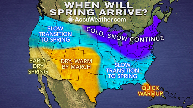
Robert Valenzano

Showing posts with label snow. Show all posts

Tuesday, March 11, 2014

How to Store a Snow Blower

Just one more time pushing that snow blower before you can put it away for next year. Snow is coming to the upper Midwest and Northeastern United States, and it will definitely be enough to justify breaking out the snow blower one last time.

However, that looks to be the last big snowfall of the season. So you'll likely be interested in how you can go about properly storing your snow blower through the summer. You definitely don't want to just push it to the back of the garage and forget about it.

Below is a list of things you should do to ensure an easier start next winter:

1. Drain the Fuel - Use a gas can to store it over the winter with some fuel stabilizer. If you don't want to, at least add fuel stabilizer to the tank.

2. Remove the Spark Plug - Follow the spark plug wire to find where it's attached, then remove it with the appropriate sized socket wrench. Store it in a clean dry place where it wont get lost.

3. Consider pouring a small amount of oil onto the pistons through the spark plug hole to prevent rusting or corroding of engine parts.

4. Cover it with a snow blower cover to make sure it stays clean and protected.

Friday, February 28, 2014

Titan Storm Spreads More Snow Coast to Coast

Winter Storm Titan
I'm sad to deliver bad news, but more cold winter weather is on its way.

Winter storm Titan, the latest ice and snow storm, is scheduled to dump more snow and ice across the US from coast to coast on Sunday and Monday.

Snowfall is expected to exceed 6 inches across the majority of Ohio. If you think that's bad, there's also a band of much heavier snow that will follow, dropping approximately 10 inches of snow somewhere. Meteorologists still don't know where that snow will fall.

The National Weather Service states that winter storm Titan is set to drop heavy snow from California to New England. It's also possible that it may drop sleet and freezing rain from the Plains all the way to the Mid-Atlantic States.

While most of you likely have gotten a snow blower by now, those of you who haven't likely won't worry about it until next winter. With winter nearing the end, and it is (only a couple of weeks left), many of us need to consider what will happen to all of the snow when late March or April showers begin washing it away.

Sump pumps are the concern now. I know I personally need to get a battery back-up sump pump because I live on a large pond in a neighborhood that often floods. My pal Jim is a sump pump expert over at Sump Pumps Direct, and he's great when it comes to finding you the perfect pump for your needs.


Friday, January 31, 2014

Is There Any End in Sight?

To many of us, it seems like winter will never end. As soon as the temperature rises a bit, it drops again. Next thing you know there's more snow.

But one of these days the groundhog is bound to find its shadow missing, and we'll be able to celebrate the start of spring.

Some parts of the country however will be able to celebrate earlier than others.

Southern California, Nevada, and Arizona will be the first to experience an early, dry spring. With recent droughts causing problems for some communities, they'll be sure to welcome the possibility of spring showers.

Southern Utah, Colorado, much of Kansas, Western Oklahoma, Western Texas, and all of New Mexico will come in a close second, finding warm, dry weather by March.

Washington, Oregon, Northern California, Northern Nevada, Idaho, Montana, Wyoming, South Dakota, much of Nebraska, Iowa, Missouri, Arkansas, Louisiana, Mississippi, Tennessee, Southwestern Kentucky, North Carolina, South Carolina, Georgia, Alabama, and the southwestern half of Illinois will have a slow transition to spring.

The Northeastern United states consisting of much of North Dakota, Minnesota, Wisconsin, Northeastern Illinois, Indiana, Ohio, Michigan, West Virginia, Virginia, Pennsylvania, New York, Vermont, New Hampshire, Maine, Connecticut, New Jersey, Deleware, Maryland, and Massachusetts will remain cold with continuing snow possibly into early spring.

Snow Blowers
Single-Stage Snow Blowers
Two-Stage Snow Blowers
Three-Stage Snow Blowers
Power Brushes
Tractor Mounted Snow Blowers and Plows Blades

Thursday, January 30, 2014

As Promised, Here it Comes!

Clearing Snow With a Power Brush
Being called Winter Storm Maximus, a wave of snow accompanied by a band of sleet and freezing rain is making its way from the Central Plains to the Northeastern US today.

Minneapolis, Minnesota is already seeing the effects this morning with snowfall of up to 3 inches complicating people's early morning commutes.

Chicago and Milwaukee are expected to experience this snowy driving hazard this afternoon and evening; so be sure to take care driving home today.

Today's snow wont be the end of it though. Friday and Saturday snowstorms bring sleet and freezing rain to cover the Ohio Valley, Mississippi Valley, Great Lakes, most of New York, and parts of New England.

While it wont be a severe crippling blizzard, snowfall accumulations in areas stretching from Nebraska to Michigan are expected to reach around 6 inches by the time both waves have passed.

Shop 2014 Snow Blowers
Top rated snow blowers of 2014
Cub Cadet Snow Blowers
Power Brushes
Tractor Mountable Snow Blowers
Tractor Snow Plow Blades
Tractor Tire Chains
Three Stage Cub Cadet Snow Blowers
Single Stage Snow Blowers
Truck Mountable Plows

Monday, January 27, 2014

How to Tackle the Approaching Snow in Northern States

Cub Cadet Snow Blower
I hate to be the messenger on this one, but it's not over yet! Coming soon to a neighborhood near you... a lot more snow. And it's not going to be light and fluffy either.

East of Lake Ontario, it's predicted there'll be over a foot of snow coming. It's possible they may get as much as 18 inches.

The rest of the area east of the Great Lakes is expected to get several inches, possibly accumulating up to 5 or 6 inches.

This snow will be lake effect snow created by cold air moving over the Great Lakes, and the snow will be damp and heavy to shovel.

If shoveling is getting you down, you could try using an electric snow shovel in areas that are only getting another inch or so.

If you're east of Lake Ontario, it may be a good idea to research the most current snow blower ratings to find out what model of snow blower or snow thrower will fit your needs as well as your budget.

If you've already got a riding lawnmower, you could get a tractor mountable snow blower or plow blade to make the job easier.

Whatever your case, the reviews at Snow Blowers Direct can help you narrow down all of the best available models to find the best snow blower for you.

Stay warm, stay healthy, and keep clearing that snow. Eventually Spring will return, but until then, try letting some modern technology help you through the season.

Tuesday, December 17, 2013

America's Winter Wonderlands

Valdez, Alaska - February 2012
The NOAA's National Climatic Data Center collected 30 years of annual snowfall data, and the results will guide you to the snowiest winter wonderlands in the U.S.

In these places, you definitely don't want to get stuck shoveling. If you live in one of the following six areas, it's time to seriously consider a quality 30+ inch snow blower!

Starting off with the number six spot...

#6 - Boonville, NY

  • Average annual snowfall = 193.7 inches
  • Most snow in a day = 35 inches
  • Record snow depth = 80 inches
#5 - Lead, SD
  • Average annual snowfall = 201.4 inches
  • Most snow in a day = 52 inches
  • Record snow depth = 73 inches
#4 - Truckee, CA
  • Average annual snowfall = 202.6 inches
  • Most snow in a month = 44.3 inches
#3 - Hancock, MI
  • Average annual snowfall = 211.7 inches
  • Most snow in a day = 26.5 inches
  • Record snow depth = 73 inches
#2 - Crested Butte, CO
  • Average annual snowfall = 215.8 inches
  • Most snow in a day = 31 inches
  • Record snow depth = 120 inches
#1 - Valdez, AK
  • Average annual snowfall = 326.3 inches
  • Most snow in a day = 47.5 inches
Valdez, Alaska - Winter of 2012


For two-stage snow blowers and three-stage snow blowers, let the snow blower expert at Snow Blowers Direct help you find what's right for your needs.


Monday, December 16, 2013

More Snow on the Way


Tuesday's ForecastJust as you're approaching the end of your snow clearing efforts for the week, we are now being told that there is more on its way. While the southwestern United States is experiencing warmer than average temperatures, the northeaster United States is experiencing the complete opposite with record-setting snowfall in some areas.

If you're still using a shovel rather than a snow blower, you can plan to get quite the workout this winter. Just northeast of the Great Lakes, some areas may get as much as 8 inches or more of snow on Tuesday, December 17th. The Chicago area and other parts of the Midwest are currently getting a couple of inches of snow, but it wont grow too significant until it passes over the Great Lakes.

New York will be getting 2-6 inches of snow Tuesday morning, putting a damper on morning commutes. This snow will also be hitting the Boston area, and coastal Maine may get even more snow.

Fortunately, the temperatures are expected to rise above freezing later in the week, so the accumulation shouldn't last too long. Remember as you're shoveling and even snow blowing, don't overdo it. Shoveling is a strenuous activity that is a great form of exercise, but can also be dangerous for those who are not in good health.

If you're not in your prime, it may be wise to invest in a snow blower or a plow. For large driveways or neighborhood sidewalk clearing, you may also consider going with a power brush. If you do choose to shovel, be careful to take your time and drink plenty of water. It's not recommended that you shovel first thing in the morning, as this is the time when heart attacks are most likely to occur during shoveling. If you experience dizziness or shortness of breathe, stop and rest.


Surely this wont be the last snowfall of the season, so you might as well prepare for more.


Thursday, December 5, 2013

Winter Storm Cleon: Bringing Loads More Snow to the West

If you're living in the West Northwestern United States, you've already seen the effects of winter storm Cleon. Since it blanketed several states with many inches of snow, we've seen areas struggling with transportation as well as very low temperatures. States bound to be most strongly effected by Cleon are preparing for the worst. As snow blowers are selling out of stores, you may need to look online. Snow Blowers Direct has many models in stock for these kinds of situations, and most of them are available with free shipping.


TEXAS
Texas has already been hit with snow, but now comes the worry of more snow as well as ice and freezing rain. Dallas is facing the likelihood of gridlock and shutdown tomorrow (Friday, December 6).

Texas Governor Rick Perry activated the Texas National Guard to bring emergency supplies to Wichita Falls and Sherman, and the Texas Dept. of Public Safety says that travel is not recommended in the affected areas.

OKLAHOMA
The entire state of Oklahoma is being placed under various storm warnings and advisories throughout the course of winter storm Cleon. 

The entire south central and southeastern parts of the state are under an ice storm warning through 6 p.m. Friday due to an expected 3/4" of ice. Other areas of Oklahoma are expected to get up to 6 inches of snow.

ARKANSAS
Starting at 6 p.m. today, Arkansas will be under a NWS ice storm warning in effect for the Interstate 40 corridor and other areas. The warning will remain in effect through 6 p.m. Friday. The warning includes Little Rock, Arkansas, and it stretches from the western border to the eastern border, covering most of the state.

Currently, much of the state is experiencing rain. By later this afternoon, the rain will change over to freezing rain. It's important to take extreme care while driving home from work, and if possible, park your vehicles in a garage to prevent your doors and windows from being frozen shut in the morning.

KENTUCKY
If you were saving your grocery shopping for the weekend, you might be in trouble. The anticipation of extreme ice and snow has already led many area residents to stock up on supplies, leaving many grocery store shelves empty.

Stock up immediately and get home before it hits. You don't want to be one of the only people taking your chances driving from store to store trying to find something for dinner.

MISSOURI
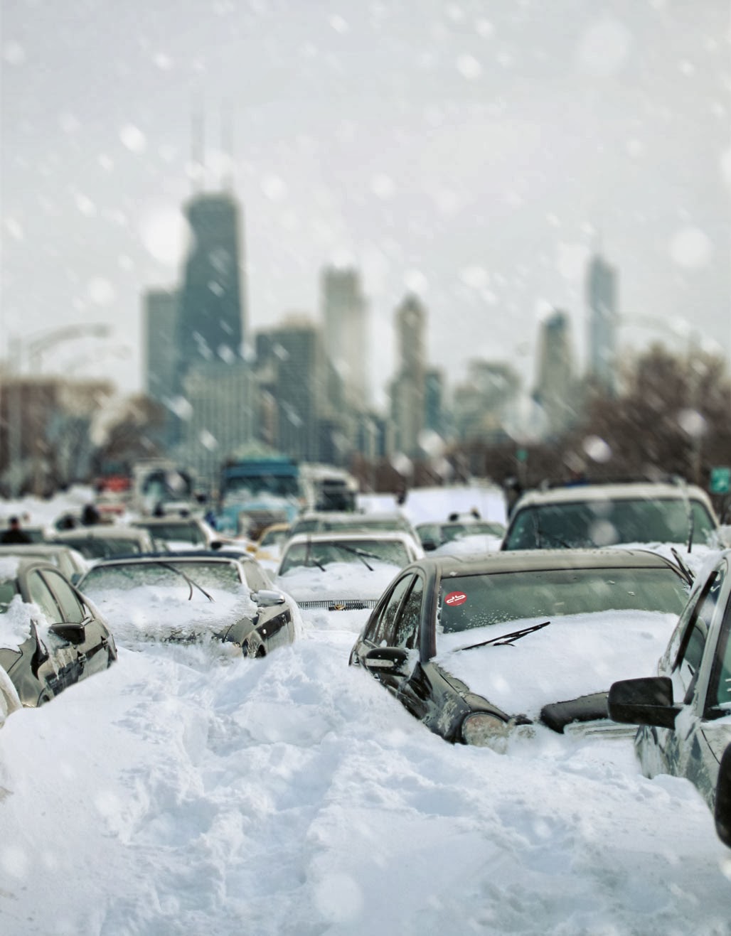
Dramatic change is the story here. Missouri had just been experiencing beautiful spring-like weather when a sudden onset of bitter cold, snow, sleet, and freezing rain pummeled the area. The southwestern part of Missouri are expected to get up to 8 inches of snow by tomorrow evening with highs reaching only into the 30s. 

Just yesterday, many of these areas were experiencing highs in the 60s, so the dramatic 30 degree change came literally overnight.

ILLINOIS
After just being hit by tornadoes, some small town areas of southern Illinois are praying they aren't hit by the winter storm as cleanup efforts are still unfinished. 

In some areas, cleanup efforts are having to be put on halt while water lines are covered to prevent freezing and city workers prepare to treat the roads.

COLORADO
While some parts of the state are experiencing ice and snow, the northwestern part of the state is seeing a dramatic drop in temperature to nearly 30 degrees below zero. 

No major highway closures have been reported yet, but these bitter cold temperatures pose seriously dangerous conditions for those wishing to travel.

NEW MEXICO
With some school closures and delays, the Department of Transportation has stated that Interstate 25 between Colmor and Raton, as well as between Rowe and Watrous, will have very difficult travel conditions because of moderate snowfall.

MINNESOTA
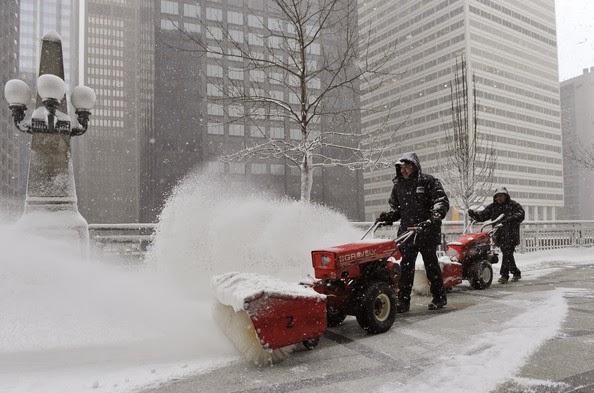
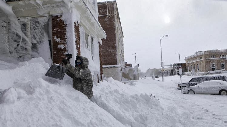
The winter storm warning associated with Winter Storm Cleon has ended for Minnesota, but not before causing plenty of havoc. Many parts of the state were covered in 2-3 feet of snow. Hundreds of accidents occurred as a result of the storm, and half a dozen fatal car wrecks took place since Monday. The Great Lakes harbor town of Duluth, Minnesota was covered in over a foot and a half of snow.

City road crews for Duluth worked 16-hour shifts clearing snow the last three days. This is an area where single-stage snow blowers may not be enough. Three-stage snow blowers are great for situations like this where you may find a mountain of plowed snow at the end of your drive. 

UTAH
Southern and eastern Utah got hit pretty hard by Winter Storm Cleon as it dropped around 30 inches of snow on parts of the state. The storm led several dozen drivers to slide off the road and get into accidents. 27 crashes were reported by Tuesday afternoon.

MONTANA
Near Great Falls, Montana, as Winter Storm Cleon swept into the area, a four-vehicle pile-up resulted in the death of a 21-year-old woman. While the storm may have passed, the driving conditions may not be favorable, and extreme cold temperatures pose a serious risk for anyone who's not prepared. Temperatures have dropped to more than 20 degrees below zero, and officials are warning residents to take precautions and stay indoors whenever possible. The temperature drop poses the risk of frostbite.

WYOMING
The storm has moved on from the area, but not without leaving residents with less-than-desirable conditions. Major highways are still open, but poor driving conditions led to several vehicle accidents yesterday. Bone-chilling cold effects the entire state. Laramie is expected to get wind chill temperatures as low as 50 degrees below zero. Several areas throughout the mountains in the western and the central parts of the state saw snow in excess of 1 to 2 feet. People in these areas deserve to treat themselves to a mid-grade two-stage snow blower. A couple feet of snow is quite the chore to shovel, and even quite the chore for an electric or single-stage snow thrower.

Stay warm and stay dry, and take every precaution with the extreme cold temperatures this next week. 

If you're in need of a snow blower, check out Snow Blowers Direct. For those effected by power outages, Electric Generators Direct has many models in stock and ready to be shipped. And as always, experts are standing by, ready to help you with any questions or concerns you may have.

Thursday, November 21, 2013

Will There Be Snow on Thanksgiving 2013?

Recipe for the perfect chilly turkey!
So many of us find ourselves piled into the family vehicle on Thanksgiving Day, traveling to the in-laws or grandparents' home with thoughts of turkey, stuffing, casseroles, and of course the excitement of seeing our favorite football team bring us a much needed win.

That brings me to the question on everyone's minds. Will there be snow on Thanksgiving? If you're in the northern US, you're probably expecting snow. And if you're one of the millions of people traveling, as gas prices this year are lower than they've been since 2010, then you'll want to know what kind of weather you'll be up against.

If you're traveling between Wisconsin and California, you'll be in luck. The Northern Plains and the West are going to be mostly clear and dry. The West will have dry and mild conditions while the Northern Plains will have very cold weather with the possibility of some flurries near the Great Lakes. Nothing too harsh or alarming, but if you're traveling south or east, you may want to bring snow blowers for gifts, or electric snow blowers for the grandparents.

There is a cold front that will move south through the Northern Plains, bringing the cold weather I mentioned to states such as Minnesota, Wisconsin, Illinois, and Iowa. But as that cold front passes into Tennessee and Kentucky, it'll be met with a path of rain and low pressure moving east northeast from the Gulf.

The outcome of this is still uncertain, but if the cold front presses on into the rainstorm, there is likely to be a good amount of snowfall covering the eastern and southeastern United States. If the cold front hangs back as some meteorologists predict it will, there may not be snow, but instead rain and ice.

Whatever the outcome turns out to be, it's important that those traveling east or southeast on Thanksgiving be very careful and keep safety in mind. Equally as important, be sure to bring your appetite and have a warm, happy holiday season with your friends and family.


Tuesday, November 19, 2013

The Top 10 Blizzards (1991-Present)

We've had a mild summer, but winter's rolling in. We can only imagine what kinds of winter storms lie ahead, but there's likely to be a white Christmas this year.

Just for fun, let's climb aboard the Snow Blowers Direct time machine and go back to 1991 for a fun and fluffy white recap of the top ten blizzards of the last two decades.

The Halloween Blizzard of 1991
As our time machine lands, we see the date is October 31st, 1991. Children are wearing snow gear with their costumes, and candy is being accompanied by hot chocolate. An early season snowstorm developed along a cold front that took a due North path along the Mississippi River and intensified as it passed through Illinois. Eastern Minnesota and the great North Woods of Wisconsin were pummeled by two feet of snow! Some areas in the north, including Duluth, Minnesota, got over 3 feet of snow! Heavy wind gusts blew snow into drifts reaching 5-10 feet high.

Superstorm of 1993
Jumping forward to March 12, 1993, an insanely intense superstorm dubbed the Storm of the Century stretched from the Gulf of Mexico to Massachusetts. The storm dumped a foot of snow on Alabama and over three feet of snow on New York. However, the biggest snowfall of this storm took place in the
mountains that stretch along the Tennessee and North Carolina border. Along this stretch of mountains fell a mind-blowing five feet of snow! 70 mile per hour winds blew drifts 20 feet high.

The Blizzard of 1996
Let's head east to New England as our time machine takes us forward to January of 1996. A major snowstorm that developed in the Gulf of Mexico moved through the Southeast United States, growing stronger along the Mid Atlantic coast. It's the great Blizzard of 1996! The storm swept into Philadelphia with 30.7 inches of snow, the greatest snowstorm accumulation ever recorded in the area. With wind gusts reaching 60 miles per hour, drifts exceeded 5-8 feet in many areas. Along with five-dozen casualties, the storm also brought upon more problems. Just a week later, rain swept through and temperatures increased, melting the snow and producing significant floods throughout the Northeast.

The President's Day Blizzard of 2003
Covering nearly the entire northeastern United States, the President's Day Blizzard dropped an average of two-feet of snow. While not as large as some of the other storms, The President's Day Blizzard covered a very large area with consistently large amounts of snow, affecting many people.

Ohio River Snow Storm of 2004
The fine people of southern Indiana, Ohio, and northern Kentucky must have been praying for a white Christmas. As we move ahead to December 22, just days before Christmas, a large storm system brought two days of snow to the area accumulating one to two feet in some areas. Heavy 20 mile per hour winds with frequent gusts exceeding 40 miles per hour created large drifts. The storm caused over $703,000,000 in damage and lost business expenses.

Blizzard of 2005
As an unusual type of blizzard formed over the Great Lakes, it moved east southeast toward New England. We find ourselves now in New England where heavy snowfall and high winds make it hard to see. Although the Upper Midwest only got approximately 5-13 inches of snow, southern New England and areas around Boston got as much as 37 inches of snowfall. In addition, high winds with gusts exceeding 60 miles per hour in the Midwest and gusts up to 85 miles per hour in southern New England caused white-out conditions, shutting down entire cities throughout the Northeast. In some areas of Massachusetts, snow drifts were reported as high as 6 feet.

Northern Wisconsin Spring Snow Storm of 2006
Let's take a Spring fishing trip to the North Woods of Wisconsin. We touch down in Gile, Wisconsin, a small community northwest of the Eagle River chain. It's March 13, but unfortunately we're not going to be doing any musky fishing. Instead, we're here to fish for a major storm. A surge of moist air traveling up from the gulf mingled with cold air as it crossed the West Great Lakes. This brought wet, heavy snow. The heaviest snowfalls accumulated between northwest Wisconsin and the Upper Peninsula of Michigan, covering "God's Land" with an average of two feet of snow. The greatest accumulation of snow took place in Giles, Wisconsin with a total of 32 inches.

Late Spring Blizzard of 2008
Blasting forward to April of 2008, we see a storm brewing in the Northern Plains. Heavy rainfall spread across Minnesota and Wisconsin. As the rainfall mixed with cold air in eastern South Dakota and northern Minnesota, snow was created. A heavy band of snow was generated from Ely Minnesota to Grand Rapids Minnesota, and 24-32 inches of snow was dropped. This blizzard stands as one of the greatest late spring snowstorms in the United States.

The Post Christmas Storm of 2010
We move ahead to Christmas, but we're just too late for presents. Initially, lows in the states surrounding the Gulf of Mexico created a storm producing a half-foot of snow and dropping it on parts of the Dixie Valley. The storm then quickly intensified as it traveled up the East coast and became a "Nor'easter," curling inward from the northeast and producing 12-23 inches of snow in the Northeast United States.

The Groundhog Day Blizzard of 2011
Set the controls to February 1st, 2011. This was the start of an incredible and historic snow storm that affected nearly 100 million people. The Groundhog Day Blizzard brought cold air, very heavy snow, wind, and mixed precipitation from New Mexico and northern Texas to The far Northeast. 

The Chicago area got hit hard, seeing as much as 2 feet of snow and blizzard conditions. Winds over 60 miles per hour created large drifts in the Chicagoland area and many roadways and airports were forced to shut down. Lake Shore Drive, a major roadway in Chicago running along the lakefront, had hundreds of cars stuck and forced to be abandoned as conditions worsened. 

The blizzard didn't stop there however. it kept moving north affecting Toronto Canada. Other areas affected by the storm were Tulsa, Oklahoma City, Kansas City, St. Louis, Springfield, El Paso, Las Cruces, Des Moines, Milwaukee, Detroit, Indianapolis, Dayton, Cleveland, New York, and Boston. Even unusual areas such as Albuquerque, Dallas, and Houston were strongly affected. Northern Illinois accumulated as much as 20-28 inches of snow.


Don't be left unprepared. Snow Blowers Direct has got plenty of snow blowers in stock, so use our snowblower ratings and snow blower buyers guide to find the perfect one for your needs now while there's still time!

Tuesday, October 15, 2013

Record Setting Blizzard Leaves Tens of Thousands of Cows Dead

South Dakota ranchers continue uncovering dead cattle and horses after a record-setting blizzard swept in and dumped over 55 inches of snow, burying cars, houses, and a catastrophic number of cattle.

With beef cattle being a major part of South Dakota's economy, many ranchers are struggling to get back on their feet. Unfortunately, while they could typically rely upon the Livestock Indemnity Program and other federally run programs funded under the Farm Bill, the Farm Bill expired October 1, leaving them without any relief measures in place.

In the meantime, the Black Hills Area Community Foundation has put together a relief fund for local ranchers in need. While this is helpful, it's not enough. However, once the Farm Bill passes, the federal money will go a long ways in helping to restore these ranchers to where they need to be.


Rapid City, South Dakota has been recovering quite well, clearing streets, and repairing the many fallen electric poles. The massive amount of snow may be cleared from the roadways, but as it melts it poses another problem - flooding. People of many different areas of South Dakota are working their days away toward recovery.

Snowfall in the 1-4 inch range is still possible for parts of the Black Hills of South Dakota, but a bit of calm tranquility is in store. While mild to moderate snowfall is possible, and the weather is still chilly, there is a "light at the end of the tunnel." 

Now is a good time to order a snow blower or a power brush. With this only being October, it's quite possible snow could be a major part of the upcoming winter.